Dec 292013
 
Partially stacked stone pile, Little Mulberry Park, 26 December 2013

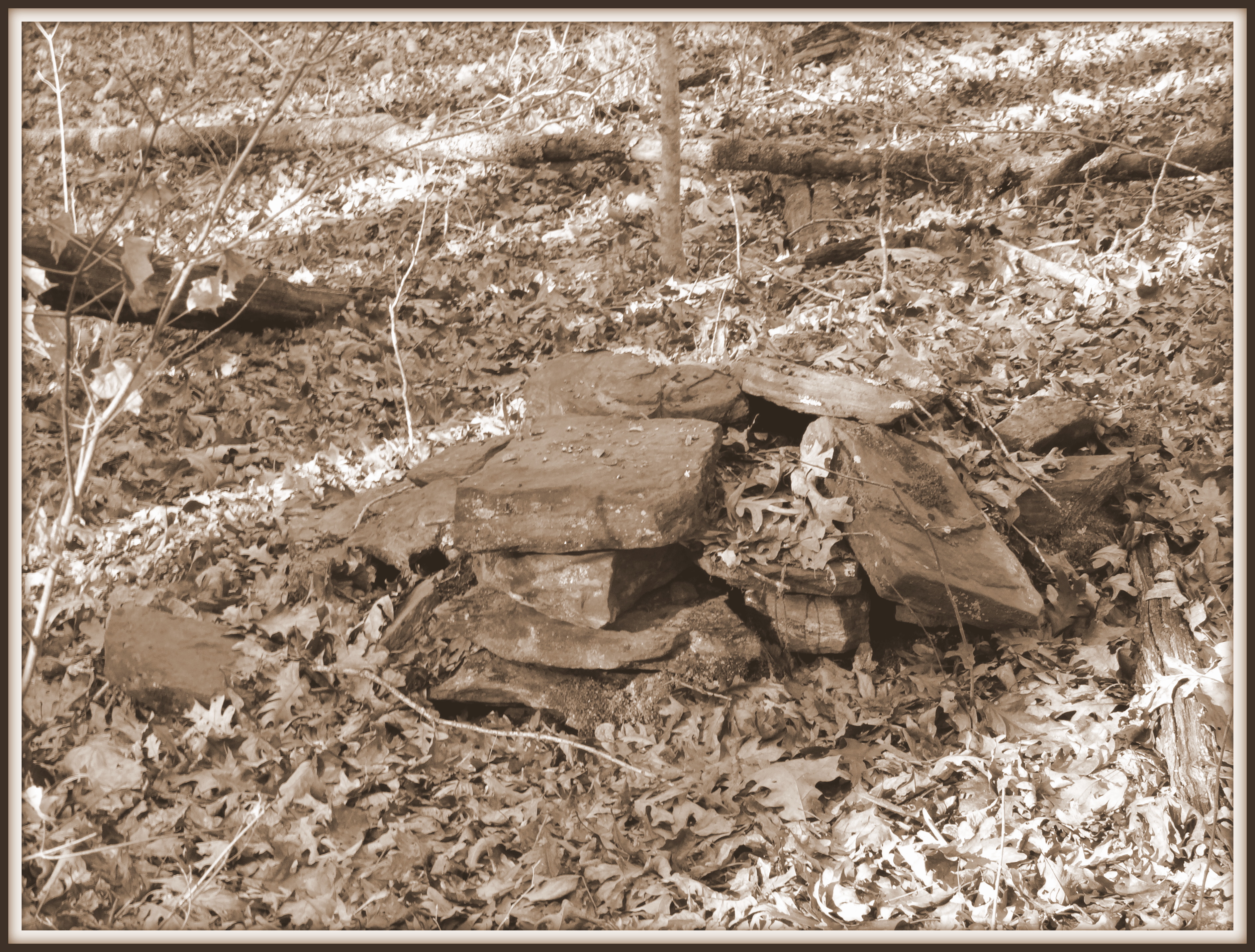
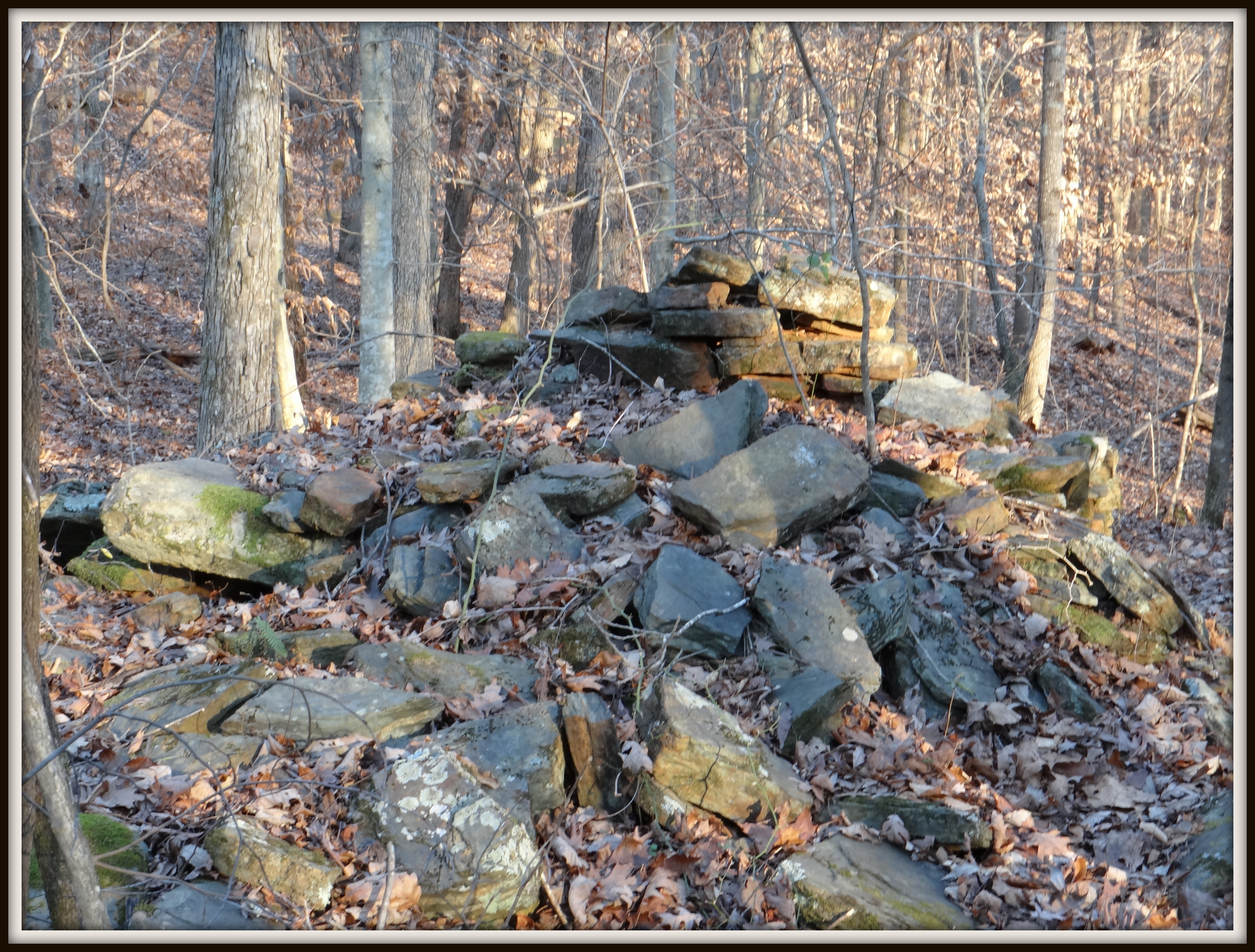
Partially stacked stone pile, Little Mulberry Park, 26 Dec. 2013

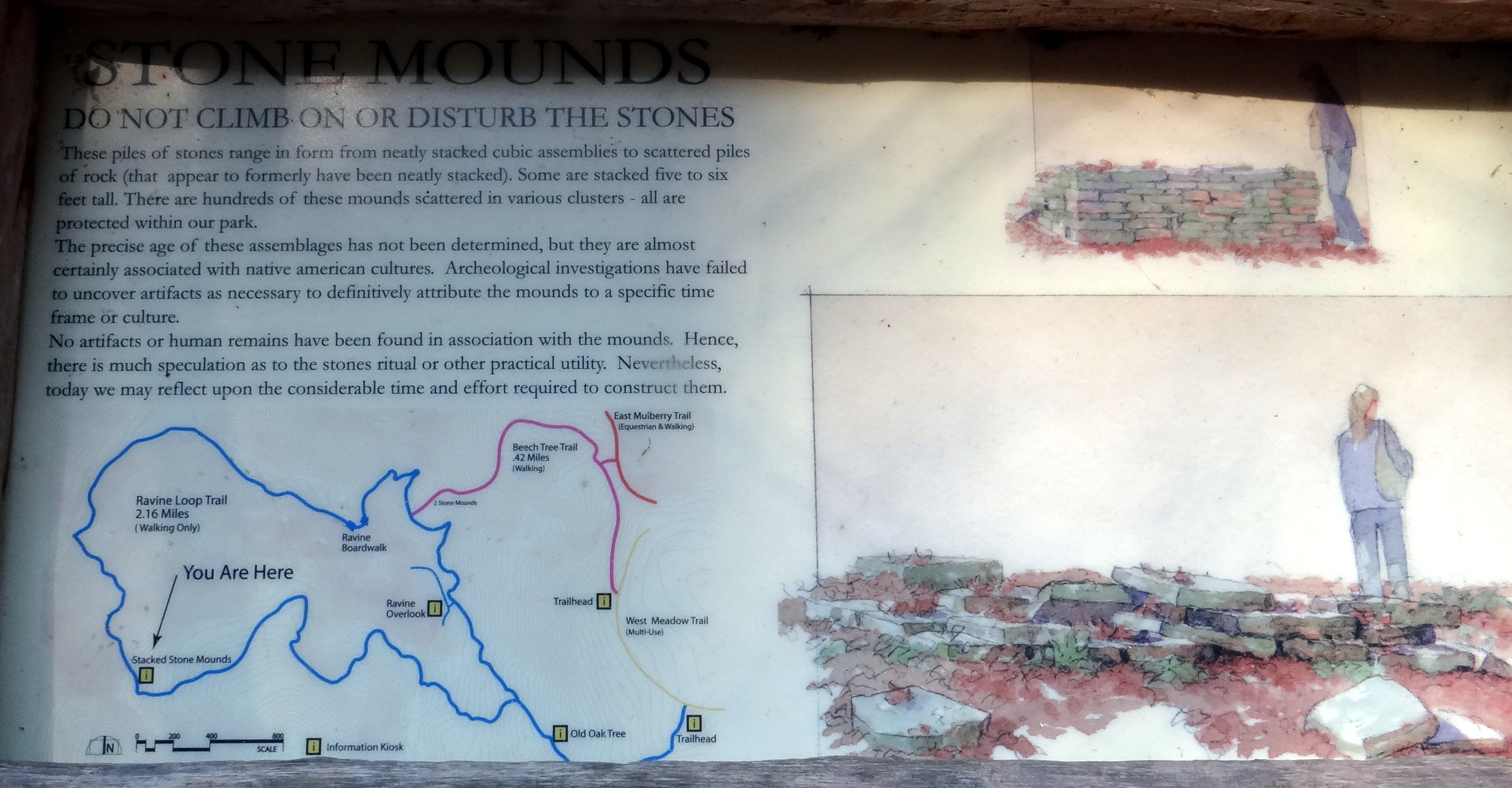
Returning home from my visit to Little Mulberry Park in Gwinnett County, I set to work finding out what I could online about the origin and purpose of the mysterious stone piles I had seen.  Were they “almost certainly associated with native american cultures” as the information sign in the park indicated?  If so, how old were they, and what evidence has been found linking them to prehistory?  The more research I did, the more convinced I became that “almost certainly” is, almost certainly, not an accurate phrase to use.  Indeed, the Little Mulberry Park Master Plan drafted in 2001 did not offer a definitive explanation for the piles, instead noting that “the stacked stone mounds have been variously attributed to pre-Columbian habitation by Native Americans and to post-settlement agriculture….”  Based upon this uncertainty, the master plan added, “it is intended that appropriate interpretive signage will be placed to present the various theories about the mounds” [emphasis added].  Various theories?  What do we truly know about these stone piles, and what is conjecture?  Where is the evidence?

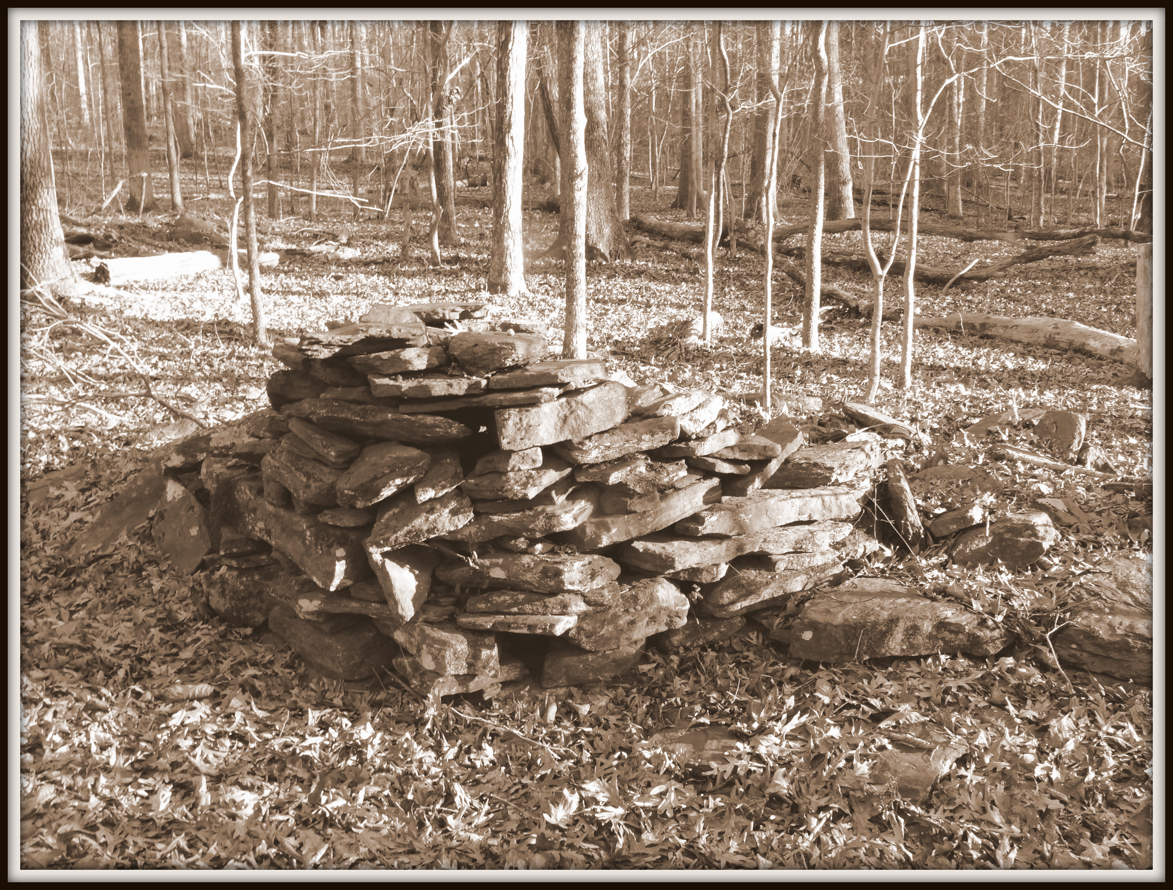
Clearly, I thought, there must be some fairly strong evidence leading archaeologists to conclude that the mounds are prehistoric.  In 1989, the site (officially termed the Parks-Strickland Archaeological Complex) was added to the National Register of Historic Places, where it is listed as a prehistoric site dating from between 499 BC and 499 AD.  According to the National Recreation Trails website (hosted by AmericanTrails.org),  the site’s “pre-historic stone mounds” date to the Middle Woodland period of Native American prehistory, between 100 BC and 500 AD.  Furthermore, “Portions of the stone mounds appear to be patterned to represent a stylized serpent figure which demonstrates careful and consistent techniques of early construction.”  It should be noted that this was the only source I could find that claimed some pattern or structure to any of the mounds, beyond observations that many of the mounds show signs of rock stacking and some are roughly cylindrical in shape.

What evidence is there for ascribing a Late Woodland age to the stone structures, and what do archaeologists think they were intended to be?  It turns out that the mounds were first investigated by Atlanta archaeologist Patrick Garrow, and he is responsible both for raising awareness of the potential cultural significance of the stone piles, and for proposing and strongly advocating that they are pre-settlement in origin.  According to a May 1990 article in the Free-Lance Star, a Fredericksburg, Virginia newspaper, Garrow found over 200 rock mounds, and is quoted in the article as speculating that “I think it was a complex for burial of the dead and a ceremonial complex.”  “But,” he added, “I’m guessing here.  No one is absolutely sure.”  In fact, no Woodland period (or prehistoric in general, for that matter) artifacts were found in or near any of the stone piles, nor were any human remains encountered.

In a 1988 archaeological investigation report by Patrick Garrow and David Chase of Garrow Associates, Inc. (discussed here), the authors gave several arguments as to why the stone piles are likely prehistoric.   While some of the mounds are situated parallel to previous boundary lines, others are not.  If the piles were formed by farmers removing rocks from a field, wouldn’t they collect the stones along a property line, to keep “wasted” land to a minimum?  Also, why would area farmers bother to pile rocks in the first place, since the area was used as pasture and never actually plowed?  Why would farmers clearing a field bother to stack the rocks with so much care?  Finally, the rock piles are not random; many are located at equal distances from each other.  Wouldn’t rock piles formed by farmers clearing their fields be more randomly situated?  (Random, that is, if one overlooks the first idea, that the piles should be preferentially parallel to boundary lines.)  All of these arguments are based upon the rejection of one  alternative explanation for the stone piles: namely, that they could have been the work of post-settlement farmers clearing their land of rocks.  By arguing against this scenario, Garrow and Chase somehow managed to conclude that the piles have to be prehistoric because there is no other reasonable explanation for their origin. In short, there is not one single piece of evidence that the stone piles at Little Mulberry Park are actually prehistoric.  As we shall see in the final installment of this series, however, there is considerable evidence pointing to a different story behind the stone piles.

Dec 282013
 

A few days ago, my wife and I ventured out to a park we had never hiked in before: Little Mulberry Park in northeastern Gwinnett County, Georgia. After circling Atlanta (I hadn’t the courage to attempt the downtown route) and driving for a near-eternity through the northeast suburbs, we arrived at last at the 890-acre park. The property offers a wide variety of trails, including a number of paved multi-use routes, plus a few for horses, bicycles, and pedestrians, and a couple limited to hikers only. We had only a couple of hours before sundown, so I proposed taking the Gorge Trail loop, a 2.16-mile route through an upland hardwood and pine forest and along the edge of a gorge. I was particularly intrigued to read that the trail included over 200 stone mounds, possibly prehistoric in origin.

Setting out on the trail, we soon came to this stunning old oak tree. Its abundant lower branches attest to a time when it stood alone in a pasture, perhaps as recently as 50 to 75 years ago.

This oak tree, perhaps 150 years old, once grew in a pasture.  Little Mulberry Park, Gwinnett County, GA.

This oak tree, perhaps 150 years old, once grew in a pasture. It now stands in a mixed hardwood forest in Little Mulberry Park, Gwinnett County, GA.

After going up and down several steep hillslopes, we began seeing stone piles everywhere we looked.  Some of them were just scatterings of amphibolite gneiss (a metamorphic rock that outcrops throughout the park), while others seemed to be intentionally stacked.  Who constructed them, and why were they there?

Stacked stones on the forest floor, Little Mulberry Park, Gwinnett County, GA.

Stacked stones on the forest floor, Little Mulberry Park, Gwinnett County, GA.

A stone pile from an unknown era shows evidence of deliberate stacking.  But with what intent?  Little Mulberry Park, Gwinnett County, GA.

A stone pile in the forest appears deliberately stacked. But for what reason? Little Mulberry Park, Gwinnett County, GA.

We came to an information sign about the stone mounds, offering an explanation for them and urging visitors to treat them with respect.

Information sign regarding the mysterious stone piles, Little Mulberry Park, Gwinnett County. GA.

Information sign regarding the mysterious stone piles, Little Mulberry Park, Gwinnett County. GA.

The text above asserts that “they are almost certainly associated with native american cultures.”  But if archaeologists “have failed to uncover artifacts”, then on what basis was the connection made?  How do we know that the mounds are prehistoric in the first place?  I will explore this mystery further in my next post.  The answers, as far as I can determine them, teach us  as much about human nature as they do about the landscape history of the upper Piedmont of Georgia.

Dec 272013
 

On my measuring walk the other day, I stopped midway to take this photograph of ornamental grasses reflected in a drainage ditch along the roadside. The pattern of stripes, along with the image of the reflected grasses in the middle, reminded me of a tri-color flag with emblem (such as a coat of arms) in the center. So I shall declare it, for now, the official flag of Piney Woods Church Road.

Ornamental grasses reflected in a drainage ditch, 25 December 2013.

Ornamental grasses reflected in roadside ditch, Piney Woods Church Road, 25 Dec. 2013.

Dec 262013
 
Measuring the length of Piney Woods Church Road, 26 December 2013.

Measuring Piney Woods Church Road, 25 December 2013.

Measuring Piney Woods Church Road, 25 December 2013.

Measuring Piney Woods Church Road, 25 December 2013.

“The journey of a thousand miles begins beneath one’s feet.”  — Lao Tzu

Where does the journey of 0.44195 miles begin?  Answer:  At Rico Road, or at Hutcheson Ferry Road, depending which way one is headed — southwest or northeast.

Yesterday, armed with a 165-foot measuring tape and aided by my wife as trusty field assistant. I ventured out to Piney Woods Church Road, to measure the extent of my daily journey in the year ahead.  I am not quite sure why I decided to measure the road’s distance.  It’s length has long been an object of mild curiosity to me, given that I have walked it with my wife and our various dogs over a thousand times in the past seven years.  But, as my GIS-trained wife wisely noted, I could obtain a fairly accurate measurement without leaving the computer, thanks to Google Earth.

Part of my inspiration came, as it so often does, from Henry David Thoreau.  In Walden, Thoreau explained his decision to sound the depths of Walden Pond.  “There have been many stories about the bottom, or rather no bottom, of this pond, which certainly had no foundation for themselves,” Thoreau observed. “It is remarkable how long men will believe in the bottomlessness of a pond without taking the trouble to sound it.”‘  And in a similar way, I have journeyed Piney Woods Church Road so many times, and never set out to find out its actual distance.

There is also a term in the remote sensing field, “ground truthing,” which refers to double-checking measurements and observations made from satellite images or aerial photographs by going into the field.  I am intrigued by the phrase, because it acknowledges (in this age of technological wonders) the benefit of walking the ground and measuring the road itself.

After the first couple of 165-foot increments (measured very slowly, unwinding the tape its full length, then winding it up again and moving on), we fell into a rhythm.  I held one end of the tape, my wife the other.  In turns, we would walk the full distance, pulling the unrolled tape behind us.  When it was my turn to stand and hold the tape still, I would listen to the shrill whistle of the fiberglass tape sliding along the gravel, breaking the stillness of the late afternoon air.

Our last measurement was only a partial one.  After traveling fourteen times the length of tape from where we began along Rico Road, the last tape length was only 23 1/2 feet, to the edge of Hutcheson Ferry Road, where the stop sign reminded us to go no further.  The total distance, in feet, was 2333 1/2.  Taken twice (out to Hutcheson Ferry Road and back to Rico again), my daily journey in 2014 will be 4667 feet, or 0.8839 miles.  There is an additional distance, of course, from my back door to where the road begins.  Perhaps I will measure that, too.  Someday….

Dec 252013
 

This post marks the beginning of a blog that I intend will span at least a year, time spent investigating the wonders of the everyday, developing a more nuanced appreciation of my home territory in Chattahoochee Hills, Georgia.  The intended centerpiece of this site will be a daily series of visits to a nearby gravel byway, Piney Woods Church Road, to take daily photographs over the course of the year 2014.  Additional posts will explore natural history in and around the Georgia Piedmont, along with musings about prehistory, landscape, and the meaning of place.

Having lived over seven years now on the same parcel of land in Georgia (longer than I have lived anywhere, apart from my formative years in Pennsylvania), I have been seized with wanderlust and thoughts of hitting the road in search of another place — Utah, Florida, elsewhere.  In this blog, I will indeed spend a year “on the road” — on the same road, the one that runs parallel to and a few hundred feet beyond the wooded back edge of my property, linking Rico Road (where I live) to Hutcheson Ferry Road.  It has become as commonplace as imaginable — the site of innumerable dog walks over our years living here.  I have walked it often enough that I have probably taken the equivalent of several hundred miles of footsteps along it.  Yet all my journeys, so far, have been about exercising the dogs, about performing a necessary act.  This year, I will indulge myself in the luxury of exploring the road for the sake of the adventures I might find, the wonders I might uncover.  It is a journey inspired in large part by Mark Hirsch, who spent over a year chronicling the life of a burr oak in southwestern Wisconsin in That Tree (a book, Facebook page, and calendar now).  He found that the experience transformed his life.  Is it too much to consider the possibilities of how such an exploration as this might touch my own?  Ultimately, the experiment (currently called the Piney Woods Church Road Project)  is as much personal as scientific.  What does it mean to devote a year to visiting the same place, a year dedicated to seeing it anew every time?